Wind Cave

Wind Cave National Park in South Dakota is home to one the largest cave systems in the world. The caves, named because of the way air rushes in and out of the natural openings with so much force it can blow a hat off your head like a giant gust of wind, stretch (at least) 100 miles underground. Inside, the visitor is greeted with gorgeous caverns filled with Boxwork Calcite (found almost no one elsewhere in the world). Unfortunately, due to both ongoing elevator repairs and Covid-19 social distancing requirements, the caves are temporarily closed to tourists in 2020. Despite this, the park is still worth visiting. I really enjoyed hiking above ground near lots of wildlife and through pristine mix-grass prairies.

DSC_1507-2.jpg


How to Explore

The cave can be explored through a variety of Ranger led tours (when the cave is open). Check the official park website for tour times and reservation details. (Personal note: while I didn't get to go into the cave in 2020 as part of my National Parks adventure, I have been in the cave before as a child, and hope to return someday soon to see it again as an adult.)

Above ground, I enjoyed hiking out on the Centennial Trail and looping back on the Lookout Point Trail. This formed a 5-mile loop. Going this way will give you a good overview of park, including leading you past several meandering streams, through tall pines, and across rolling prairies. Be on the lookout for wildlife throughout. In addition to bison, which could cross your path at any time, you’ll pass through two large prairie dog towns, and a number of spots with significant nesting bird populations. The prairie dogs are a particular joy to watch.

Pro tip: when you enter a prairie dog town you will be greeted by dozens of dogs screaming to each other in a seemingness endless chorus. As long as you keep moving that will continue. Instead, if you sit still for a long time the prairie dogs will eventually calm down and some may even approach you for a closer look. Separately, while there, don’t get too close to their holes. I say this out of respect for them, and also out of care for your well being. Once off the path, you are more likely to run into Prairie Rattlesnakes, who also enjoy prairie dog towns.

DSC_1376.jpg


Photography

Photography in the cave is likely difficult as both tripods and flash photography are prohibited. However, plenty of photo opportunities exist above ground. In addition to plentiful wildlife, I really enjoyed shooting the contours and colors of the landscape. 

DSC_1384.jpg

Also, don’t forget to look at your feet as you walk. This area of the Black Hills is filled with beautiful rocks, including lots of rose quartz. While it’s tempting to grab a piece, always leave no trace, and only take photos. 

DSC_1472.jpg


Where to Stay

There is one small (61 site) established campground in the park, Elk Mountain. Sites are reserved on a first come served basis. In addition, backcountry camping is permitted in the northwestern part of the park. A free permit can be picked up in the visitor center.

DSC_1464.jpg

There are several established campgrounds outside the park to check out as well, including several in Custer State Park as well as KOA sites in both Hot Springs and Mount Rushmore

If you are looking for a motel or a lodge, the closest town to Wind Cave is Hot Springs. There are some cool things to do in town, but to be honest I wouldn’t choose to stay there on a future trip for more than one night. Instead, consider setting up a basecamp in the town of Custer or one of the lodges in Custer State Park.  

DSC_1264.jpg


Nearby Places to Explore

10 minutes to the south of park entrance is the town of Hot Springs. I got a kick out of the Mammoth Site in Hot Springs, which is an active archeological dig (indoors) containing at least 1,200 mammoth bones. The site was discovered by a developer in the 1970s who was bulldozing a hill in order to make apartments. Can you imagine what he thought when he first found all those giant bones? If you are traveling with kids, in July and August the museum offers a Junior Paleontologist program for them to participate in “digging”.

30 minutes to the north is the entrance to Custer State Park and the beautiful Pinnacles Highway.  Highlights of the park for me included Slyvan Lake, which is a great place to swim and stay (there is both a lodge and a campground there). The park also has several half day mountain hikes I really enjoyed, including Black Elk Peak and Little Devil’s Tower. 

Continuing North, you’ll arrive at Mount Rushmore, which needs no introduction, and an hour and half past there is the town of Spearfish. Hiking up to the Spearfish Falls is easy and beautiful. If you want more of a challenge you can extend the hike further to see two additional falls. 

30 minutes west is Jewell Cave National Monument. Unfortunately, like Wind Cave, the cave itself is closed in 2020 due to Covid-19. Hopefully by the time you are reading this guide it is open again. 

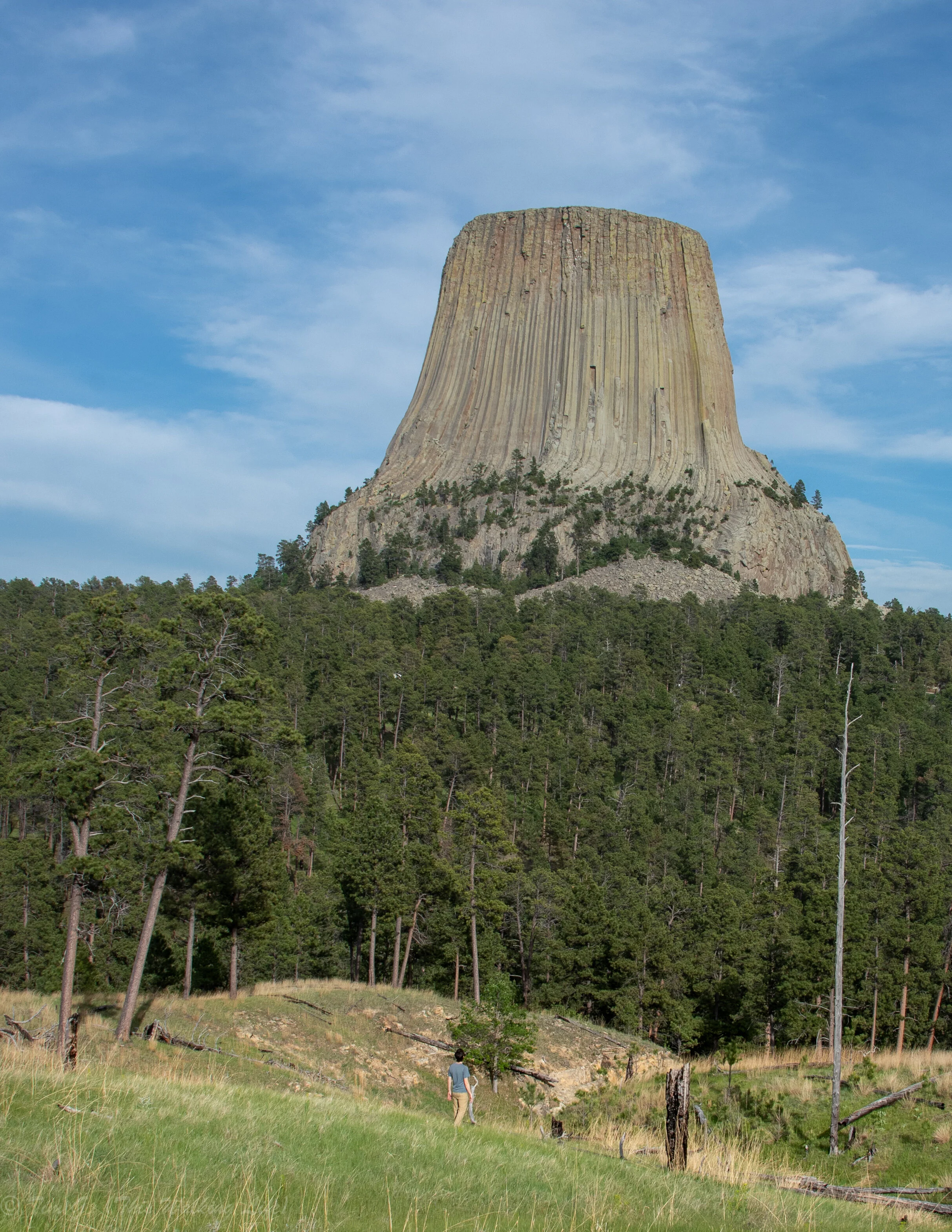
Beyond Jewell, continuing onward into Wyoming, is Devil’s Tower National Monument, a strange geological feature, rising 867 feet straight up out of the prairies. The Tower has long been sacred for many Native Tribes, and is also famous in current popular culture today for many reasons, including for its role in the final scene of Steven Spielberg’s Close Encounters of the Third Kind

DSC_1023.jpg

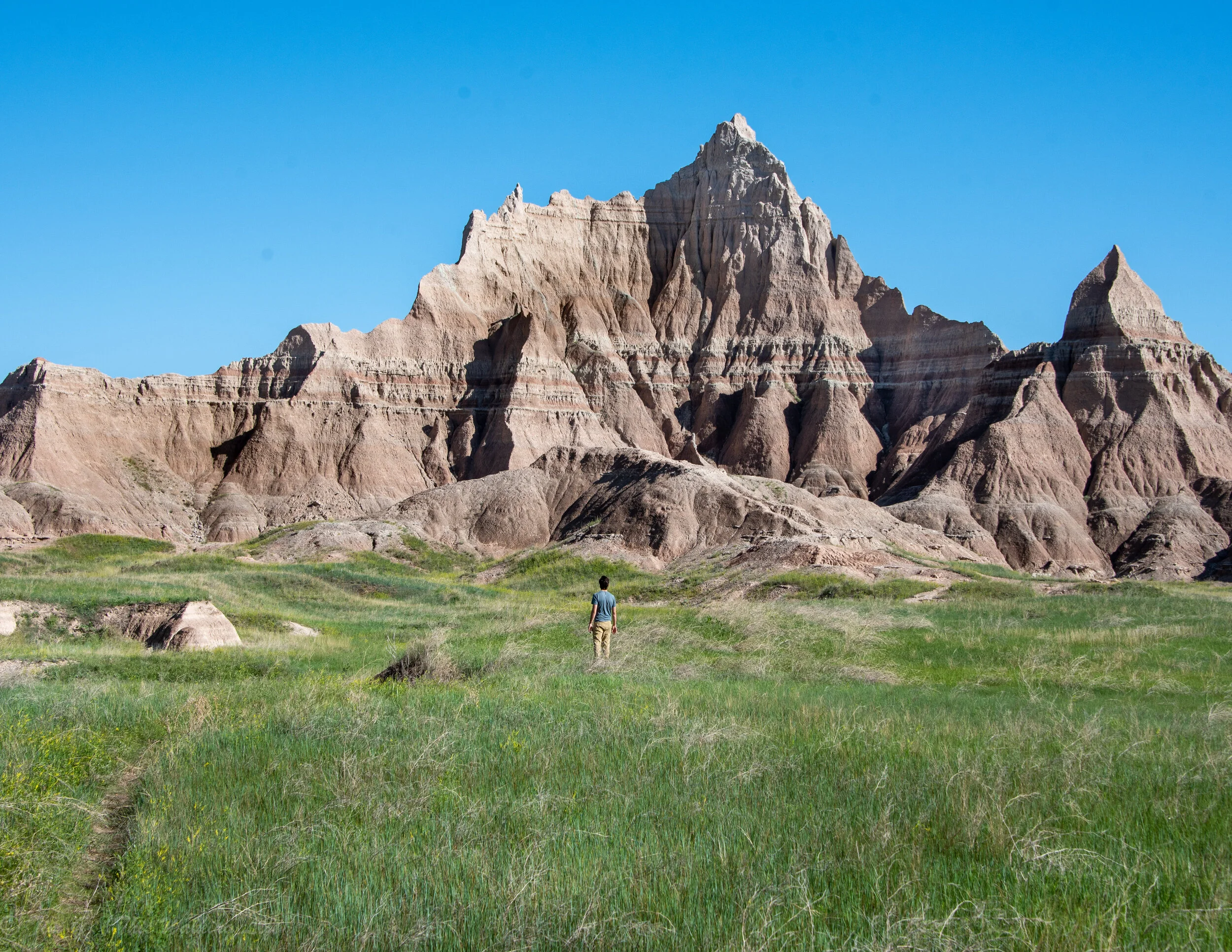
Lastly, while in the area make sure to at least drive through the Badlands National Park. (For detailed recommendations on visiting the Badlands check out my guide: here.)


Personal Reflection

As part of my project, it’s been important to me to photograph each park in a way that captures something “essential” about it. Therefore, for a park with the name “Cave” in the title, it seemed obvious to me that I needed to photograph inside the cave.

Unfortunately, before going to South Dakota, I read on the official website that the cave was closed. Should I even go if I can’t photograph what I want I wondered? After debating it for a while, I grudgingly decided to go for a few reasons. Firstly, I’d already be in the area so it wouldn’t be that inconvenient. Second, it’d be hard to return anytime soon. Third, during the first weeks of June 2020 a lot of parks that had been closed for months were beginning to open up each day. Maybe, once I got there things would miraculously open there too.  

Upon getting to the park, I headed to the visitor’s center, hoping a ranger would tell me something encouraging. Unfortunately, not only was it closed but I couldn’t find any rangers. Despite that, I got out of my car to see if I could find any more information. Sure enough, taped to the door was a typed sign (in small font) letting people know the cave was indeed still closed. As an addendum, the note added that the rangers had no idea when the cave would open again. It wasn’t just Covid-19 and the impossibility of letting people into the “small” and “confined” spaces while social distancing was necessary. No, more fundamentally, the elevator down had broken in 2019 and they “didn’t know” how long, or maybe even “how”, to fix it.

I know that on an adventure it’s almost guaranteed things will not go according to plan. But sometimes, it’s still hard for me not to be mad about it at first.

Unable to go in the cave, I decided to try to make the best of it, and instead just explore above ground for a day instead.

I’m so thankful I did. Freed of any time pressure or need to capture “the essence” of the park, I simply walked by myself and explored at a leisurely pace without real plan or purpose.

While on the trail, I sat beside a stream in the shade for a while. Later, I discovered what looked like a cave entrance up in some nearby cliffs. Upon getting closer, I saw literally thousands of swallows flying in and out of it as they tended to their nests in the rocks. (In the picture below you can see their nests and heads popping out of many of the nests).

DSC_1290.jpg

Later, I sat for over an hour in the midst of a prairie dog town, watching and listening to the creatures investigate me, care for their young, and play with each other.  

DSC_1450.jpg

The truth is, I wouldn’t have seen any of this had the cave had been open. Or even if I had, I probably would have been in a hurry (or too tired) to slowly take it in the way I did. 

The experience was a good reminder to me to have equanimity when things don’t go accordingly to plan. Of course I was disappointed and frustrated. Obviously, I don’t get the cave photographs which are important to the project I’m working on. However, because things didn’t go according to plan I also got to experience a lot of unexpected joy and beauty too. 

DSC_1485-Pano.jpg

I hope you have a wonderful time at Wind Cave National Park (and that the cave opens up soon too). As you read this and explore the park for yourself, please let me know if you have any suggestions on how to make it even more useful for others. Until then, happy exploring!

Badlands

When approaching the Badlands you are given no foreshadowing of what you are about to see. Without warning, the seemingly endless Dakotan fields and prairies disappear, replaced by a treeless Martian landscape of labyrinthian ravines, jagged ridges, and vividly colored rock spires. 

DSC_2476.jpg

The contrast between the flat, lush fields outside the park and the craggy desolation inside the park can be jarring. Rather than rushing ahead, I recommend pausing to sit with the park’s strangeness when you first arrive. Both the Pinnacles and Northeast entrances have scenic overlooks (Pinnacles and Big Badlands) immediately after you drive in. Whichever way you arrive, pull into one of them, stop, walk to the edge, find a seat, and ask yourself: “What does this place stir up inside me?”

Is it wonder? Excitement? Fear? Boredom? Disquiet? Let yourself be still and observe both the landscape and your emotional reaction to it for 10-15 minutes.

You’ll be surprised how many colors, shapes, and layers you discover (inside and out) the longer you let yourself look.

Orienting Yourself in the Park

The Badlands National Park is in southwestern South Dakota, four hours west of Souix Falls and an hour east of Rapid City along I-90.

While there are three units to this park, the vast majority of visitors only explore the North Unit, and this guide only covers that portion of the park. (Note: the Stronghold and Palmer Creek Units are both within the Pine Ridge Indian Reservation, and are not open whatsover in 2020 due to Covid-19). 

National Park map of the Badlands. Image from the official NPS website.

National Park map of the Badlands. Image from the official NPS website.

Traversing the North Unit is easy as there is really only one major paved road (called the Badlands Loop Road) which goes the 26 miles between the Northeast and Pinnacles Entrances. It doesn’t matter which way you travel on the road, but I would enter on one side and exit on the other.

Even if you are only planning a day trip, leave a few hours in order to savor this drive and stop at all of the overlooks. The drive is spectacular, cutting through dramatic rock formations and following along cliff edges with big views down to ravines and grasslands far below.

DSC_2357.jpg

Pro Tip: budget extra time to also drive the dirt Sage Creek Rim Road (really an extension to the Loop Road), which continues past the Pinnacles Entrance. Even if you are planning to end up in Wall, it’s worth it to drive the extra ~25 miles round trip to the western edge of the North Unit and back. I think this section of the park has some amazing vistas and plentiful wildlife (including an ever delightful prairie dog town).

Hiking

There are relatively few established hikes in the park, and most are near the Northeast Entrance. 

The 0.7 mile Saddle Pass Trail is good short hike. It’s steep and not suitable for everyone, but if you are looking for a short adventure, it’s fun to climb and leads to a beautiful overlook at the top. The Notch Trail is another great short hike. It’s only 1.5 miles, but is a lot of fun as it requires climbing up (and down) a ladder, travels through a beautiful canyon, and ends at a notch in a cliff wall which looks out over the White River Valley. 

DSC_2253.jpg

If you are looking for a longer day hike, the Castle Trail is the longest established trail in the North Unit (10 miles out and back). It connects the Window and Door with the Fossil Exhibit Trail parking lots. If 10 miles is too much, you can hike a portion of this trail on the 4.5 mile Medicine Root Loop. I thought the trail was interesting, but honestly it didn’t provide views that different from what’s available near many of the pull-outs. So, while I enjoyed it as a hike, I didn’t think it was a “must-do.” If you choose to hike this trail in the summer, be warned it has absolutely no shade.

Lastly, for those looking for a multi-day adventure, consider the 20 miles Sage Creek trail.

Pro Tip: given the lack of established trails, it can be fun to explore off trail near pull-outs along the ridges, but keep in mind a few things. First, if there has recently been rain (or it is about to rain), the ground can get shockingly slippery. Second, the Badlands are in a state of constant erosion, so hiking near edges can be unexpectedly dangerous. Ledges can, and do, give away without warning. Third, the Badlands is full of Prairie Rattlesnakes in the summer. They love to sun themselves on the rocks in the middle of the day.

Can you see the hiker (in white) on one of the ridges in the bottom left corner of this photo? While it was easy for him to get down, his friends had to hoist him back up when he tried to climb back up to them after I took this photo.

Can you see the hiker (in white) on one of the ridges in the bottom left corner of this photo? While it was easy for him to get down, his friends had to hoist him back up when he tried to climb back up to them after I took this photo.

 Photography

The sun glare can be intense during the days. So, be sure to budget time to shoot during the blue and golden hours. During these times you’ll treated to surprising colors in buttes and beautiful shadows.

My favorite spots to photograph were on buttes near the Big Badlands Overlook, the Ben Reifel Visitor Center, and the Pinnacles Overlook. 

DSC_2167.jpg

There’s no question the desolation and rocks make for the interesting compositions, but don’t forget to capture the life in the park as well. I especially enjoyed photographing the contrast of stone against grasslands, the desert flowers, and the large animals found throughout the park.

DSC_2259.jpg

Pro tip: Big Horned Sheep are common in the park and make a great addition to any photograph. You can find them on many of the ridges munching away totally indifferent to nearby humans. I saw the most when I was exploring the cliffs along Sage Creek Road.

DSC_1890.jpg


Where to Stay

Lodge Living: the Cedar Pass Lodge is a stones’ throw from the Ben Riefel visitor center. This site has a handful of (pricey) small cabins for rent seasonally.

Camping: there are two campgrounds in the park: Cedar Pass and Sage Creek. Please note that the Sage Creek campground has no water. Backcountry camping is also available in the park, including along the Castle Trail. Make sure to get a permit from the Visitor Center.  Extensive dispersed camping is available throughout the adjacent Buffalo Gap National Grassland.

Pro tip: strong storms with hail and violent winds can blow unexpectedly through the Badlands in the summer. If you are camping frequently check the weather forecasts.

The leading edge of a storm approaching the southern edge of the park in June 2020. I got soaked to the bone seconds after taking this shot.

The leading edge of a storm approaching the southern edge of the park in June 2020. I got soaked to the bone seconds after taking this shot.

Motels: If camping isn’t your speed, there are plenty of no frills motels in Kadoka, Wall, and Interior. They are expensive for what they are, but you are paying for proximity. Any of these tiny towns are fine to stay in. I’d pick based on wherever you are coming from and headed toward. The only caveat is that if you like tourist traps, then don’t miss the best advertised souvenir superstore (Wall Drug) in the town of Wall.  

Lastly, plenty of additional options exist in Rapid City or the Black Hills if you don’t mind adding an hour + each way to your drive.

A family of big horned sheep resting on the buttes west of the Pinnacles Overlook.

A family of big horned sheep resting on the buttes west of the Pinnacles Overlook.

 Nearby Places to Explore

If you are headed to the Badlands, budget time to explore the surrounding area as well. There are a lot of treasures in Western South Dakota that make great add-ons to a Badlands trip.

First, don’t miss the Minuteman Missile National Historic Site. The site is off the same highway exit as the Northeast Entrance to the Badlands. During the Cold War 1,000 Minuteman nuclear missiles capable of literally ending the world were hidden throughout the Great Plains, including several at this spot. Here, you can tour one of the silo and control centers. It’s unnerving, on many levels. Note that you must make advanced reservations through the website in order to visit. You can’t simply show-up and sign-up for a tour.  

An hour and half west of the Badlands is the town of Spearfish. Hiking up to the Spearfish Falls is a beautiful easy hike. You can extend the hike further, to a more dramatic set of falls if you are feeling up to it.

Further south in the Blacks Hills are a number of parks worth visiting. Custer State Park is a great place to camp, and has a few nice half day mountain hikes including Black Elk Peak and Little Devil’s Tower. If you go, be sure to drive the Pinnacles Highway. The Black Hills also contain two famous cave systems: Wind Cave National Park and Jewell Cave National Monument. Unfortunately, both caves are closed indefinitely in 2020 due to Covid-19, though Wind Cave in particular has some nice above ground hiking. (Click here for my detailed guide on exploring Wind Cave NP).

Lastly, no trip to Black Hills would be complete without a visit to the Mount Rushmore National Memorial.

Looking out over Custer State Park from the top of Little Devil’s Tower.

Looking out over Custer State Park from the top of Little Devil’s Tower.

Personal Reflection

One thing that annoys me about most guides to National Parks is the breathless way they speak about every aspect of every park as if it’s sure to bring the viewer into instant rapture, or how professional glossy pictures can imply every turn holds an effortlessly achieved sublime view. The truth is nature owes us nothing and if we approach it with an entitled attitude we are sure to be disappointed. [This led to a brilliant NPS marketing campaign a few years ago highlighting 1-star park reviews on Yelp]. 

Yes, beauty sometimes hits you over the head, but with photography (no less than with your naked eye) exploring for its own sake, finding unexpected angles, patience to wait for light to change, and willingness to sit in stillness all have the power to transform something which may seem unremarkable at first sight into an unforgettable miracle. 

DSC_2276.jpg

The Badlands is a case in point of this phenomenon. It would be easy to pass through this park, shrug, and think, “that was boring.” And in fact, that’s exactly what I thought the first time I passed through the park as a 15-year old. 

Returning to the park in my 30s, I had a different experience. This time the park again got under my skin, but for different reasons, sometimes for its beauty and sometimes for its desolation. This time, I tried to stop, give myself space to really see what was here beyond my first impressions, and listen whatever this land had to teach me.

DSC_2238.jpg

I hope you found this guide helpful. Don’t be shy to drop a comment or send me a note via the contact section of my website if you have any ideas or suggestions that could help improve this guide for future readers.